A Little Explanation:
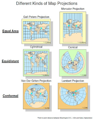
Map projections are a significant part of spatial analysis tools. They allow us to project 3-dimensional spatial objects onto 2-dimensional surfaces. This is a powerful tool because human beings observe data much better in 2 dimensions, for example, on a computer screen or a paper map. It is important to have different kinds of map projections because when transforming from 3d to 2d, not all detail is preserved, but the type of map projection allows us to determine which details are preserved.
Equal area map projects preserve the details known as area. This means that taking a section of map area and comparing it to a different section, if their areas are equal, the represent the same amount of area on the ground. It may seem intuitive that all map projections should have this quality, but it is not the case. When looking at equal area maps, it may seem like they are not equal area at all because of the sheer size of Antarctica. However, if you compare the size of America you will see that big on the map doesn't necessarily mean big on the ground.
Another type of map projections, equidistant, preserves distance rather than area. This means that the distances between points will be more accurate than other details. These kinds of maps would be desirable for spatial analysis focusing on distances between locations. As you can see, the cylindrical and conical kind look very different. You may wonder why the distances between the 2 cities vary since these are supposed to be equidistant. Equidistant only pertains to within the map, since each map may have a different scale.
Conformal projection is the last type shown on my project. Conformal maps, rather than area or distance, seek to preserve the shapes details of land areas. Both the Van Der Griten and Lambert protections do this well, and as you can see they are both round. It is common for conformal maps to not be square, because the stretching that occurs when turning a spherical object into a rectangular one destroys the forms of the shapes. Conformal maps are useful for analysis pertaining to the shapes of countries and land masses.
No comments:
Post a Comment